Transmission infrastructure projects can unlock a greener and fairer future. To get transmission projects underway without delay, it’s vital to have a sound, structured and consistent approach that demonstrates consideration of environmental, social, and technical issues to progressively analyze potential options until a preferred route is identified. These steps are supported by open, iterative and documented stakeholder and community engagement through each stage, balancing the needs of the community and the environment through the project design and development. In doing this, projects can meet functional requirements, deliver value for money for consumers and improve the social license – ultimately benefiting everyone.
Although the process presented here has been developed for energy transmission projects, it can easily be applied to any linear or site-based infrastructure, large or small. The principles are the same, even if the scale of impact differs.
The route selection process that WSP often adopts has four key steps. These steps use increasingly detailed information at each stage from stakeholder and community consultation, environmental assessment supported by desktop and/or field studies, and ongoing engineering design work. Key considerations are documented at each step to validate decision-making and allow effective communication with the community and other stakeholders.
A critical pre-requisite for the route selection process is identifying, based on an assessment of the project need (i.e. the problem that needs to be solved), potential technical options to address that need. These options should also be evaluated by balancing each against high-level technical, environmental, social, and cost factors.
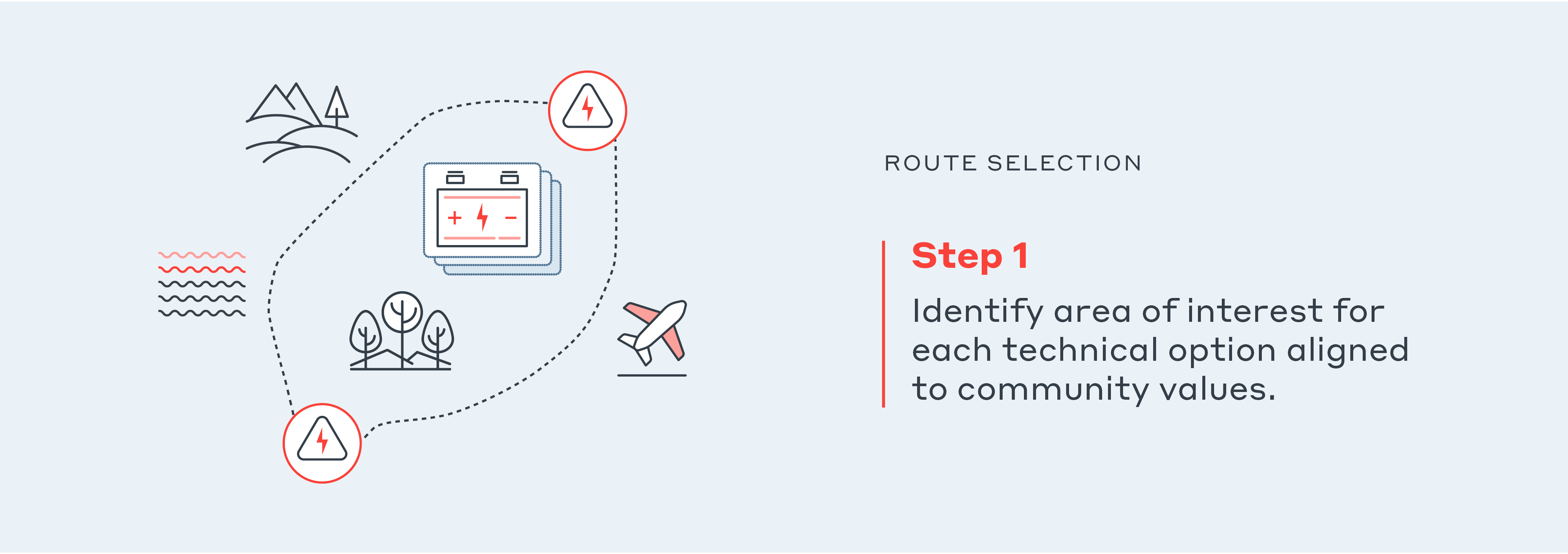
One of the goals of this stage is to identify the technical option that is most commercially efficient, technically feasible and environmentally responsible, with a socially favorable outcome in line with what the community values.
This stage requires technical, financial, environmental, and social specialists to provide a balanced evaluation of the options. Documentation of key decision making, and the supporting considerations, is important to inform later stages and to support consultation.
The other key goal of this stage is to identify a broad area of interest for technical options identified. It should be broad enough to allow reasonable flexibility and optioneering in future stages of the project’s development. This can then be used to start defining major foreseeable environmental, social, and technical ‘showstoppers’ for each option. An important factor that often gets missed at this early stage of a project is starting to identify what’s particularly important to the community and what they value in their local area.
The main output from this stage is identification and definition of the project, presumably a transmission line, with which to proceed through the route selection process.

This step involves assessing key environmental and social risks and opportunities to identify and assess broad-scale corridors within the area of interest. This should include ‘no go zones’, such as mountain ranges, urban populations, areas of high-value irrigated farming land and areas of significant environmental or heritage value (Ramsar wetlands, national parks, etc.). This stage should also include initial information from local stakeholder feedback. Project constraints and their associated weightings will be unique to the area of interest and the community’s values.
When the available information is mapped (utilizing GIS-based datasets), feasible corridors can be identified within the area of interest that maximize avoidance of no-go zones and highly weighted constraints, avoid or minimize interactions with more moderately or low-weighted constraints, and leverage identified opportunities. This is typically undertaken through workshops to identify best-fit alignments that may be readily apparent from the mapping, and/or by using multi-criteria route analysis tools.
To achieve broad community representation and to allow different voices to be heard, it is advantageous at this point to develop a stakeholder or community reference group, including diverse perspectives and representatives such as local council(s), Traditional Owner groups and Indigenous people, conservation bodies, infrastructure operators, state and local government agencies, and community members. This enables open and meaningful engagement and can help identify potential data gaps and areas important to the local community. It is important that issues raised, and feedback provided by the reference group are considered, responded to, documented, and made public. This applies regardless of whether the information is incorporated in the preferred corridor option or not.
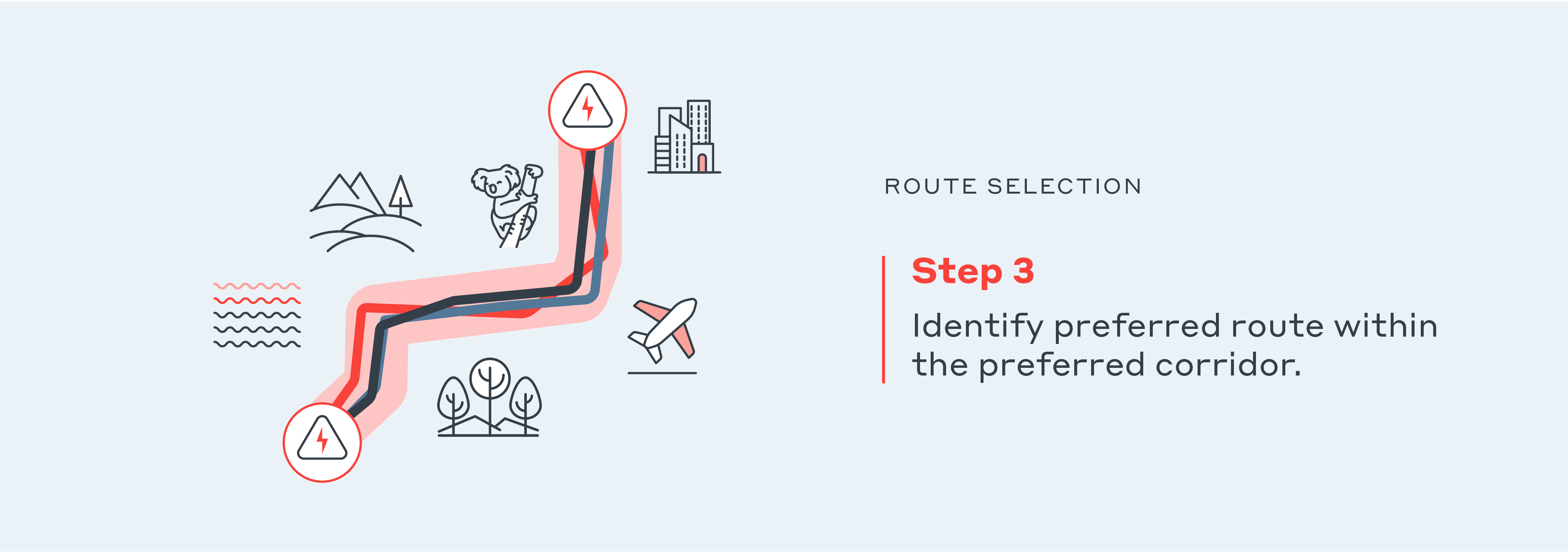
The final preferred route should be sufficiently narrow to allow comprehensive environmental studies (including field surveys) that meet legislative requirements, as well as detailed and meaningful landowner discussions.
The processes generating the route options are similar to corridor identification. They rely on spatial data sets (including increasing detail where available), as well as initial field surveys (for issues such as biodiversity and heritage) and targeted engagement with potentially impacted landowners and other stakeholders.
In some locations, decisions will need to be made to balance competing constraints, such as Indigenous heritage, threatened species habitat, disruption of existing land use and business activities, community concern, visual impacts, and constructability challenges. The process and decisions continue to include involvement of the reference group, providing them opportunities to comment on identified route options and the initial preferred route. Evaluation of this stakeholder feedback informs the final preferred route, which then undergoes the appropriate environmental impact assessment.
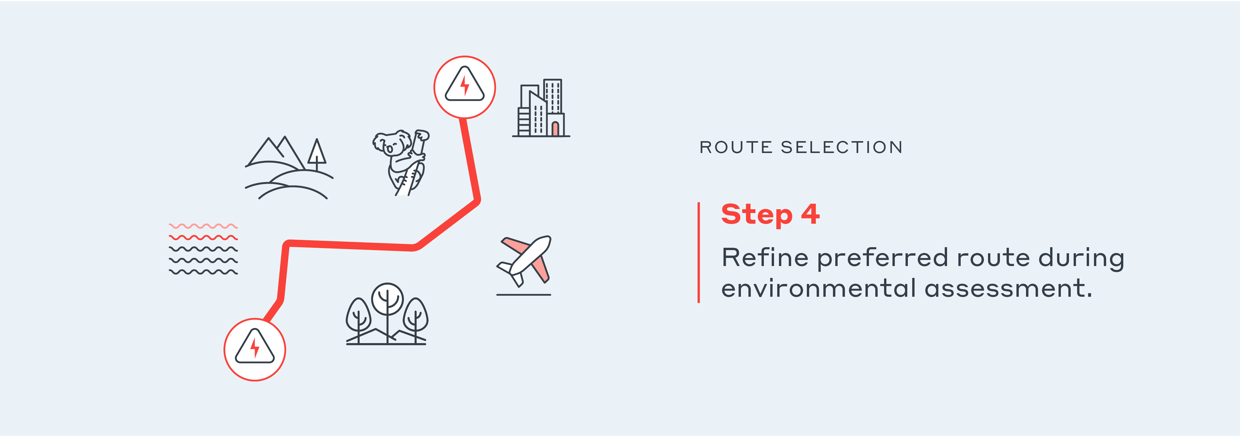
As part of the environmental impact assessment process, the route can be further refined through specific landholder consultation, detailed field studies and engineering concept designs. The environmental assessment and approvals documents are placed on public exhibition to allow community and other stakeholder feedback to be invited, considered, and documented.
Community and stakeholder engagement is crucial
WSP believes that decisions about the location of infrastructure should be made on the basis of rigorous and transparent processes that respectfully include communities along the journey.
There’s greater chance of acceptance of large, new infrastructure builds such as transmission lines when projects genuinely attempt to consult, listen, and involve the community throughout the process with a focus on co-design, social licence and ongoing social value. Continuous and genuine communication of constraints and compromises can help communities appreciate the reasons behind final project outcomes and understand the process by which decisions have been made.
Digital decision-making support
Computer-based option analysis via tools like GoldSET© can go a long way in reinforcing the way decisions are made in today’s environment. Using multi-criteria analysis (MCA) and geospatial information management - It can be an effective support in the process of identifying the most sustainable corridor or site.