Traditional tools like borehole logs and 2D cross‑sections still matter, but they often struggle to convey the true scale of a project or the uncertainty that comes with working underground. Ground models help fill that gap.
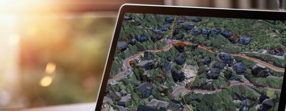
These three‑dimensional interpretations bring together geological information such as soil and rock types, groundwater conditions, and past investigations, and combine it with project data to create a single, visual picture of the subsurface.
WSP senior engineering geologist Richard Punt says the industry has long relied on one‑ and two‑dimensional views.
“Moving into 3D with ground models gives a completely different level of context. You can see how data overlaps, where it’s strong, and where the gaps are.”
Turning data into something usable
WSP builds ground models from a mix of sources, including public datasets from organisations like Earth Sciences NZ and the New Zealand Geotechnical Database, decades of internal archives, and project‑specific investigations.
Specialist software produces an initial 3D model, but that’s only the starting point.
Digital engineering modeller Jordan Miers says software gives you a first cut, but "the real value comes from experienced engineering geologists refining that model.”
As projects evolve, so do the models. New boreholes, lab results or site observations can be added, and design elements - such as road alignments, tunnels, and bridge piles - can be layered in. This lets teams test constructability, understand risk earlier, and explore ways to reduce material use and carbon impacts.
Not a crystal ball, but a very useful one
Ground models aren’t perfect. They’re interpretations, and the further they extend from areas with dense data, the more judgement is involved. But that uncertainty is part of their strength - it becomes visible rather than hidden in technical drawings or spreadsheets.
Technical principal for engineering geology Latasha Templeton says one of the biggest advantages is being able to show clients where the data is thin.
“That helps have informed conversations about risk appetite and whether further geotechnical investigations are worthwhile.”
This clarity has been especially valuable on major transport and water projects. On some projects in Tauranga, for example, WSP ground modelling helped define the extent of weak peat layers and understand the depth to rock. These insights directly shaped pile design and reduced risk early on.
WSP has applied the same approach on Auckland water pipelines, contaminated land sites and port upgrades. Across all these projects, the aim is the same - better understanding, earlier decisions, and fewer surprises during construction.
Building resilience from the ground up
Ground models are becoming even more powerful as new datasets are added. Satellite InSAR technology, for instance, can detect millimetre‑scale ground movement and link it back to subsurface conditions - helping identify settlement, compressible soils or the edges of landslides.
As infrastructure challenges grow more complex, early insight matters. Ground models won’t eliminate uncertainty, but they’re quickly becoming one of the most effective ways to manage it and design infrastructure that stands up to the future.